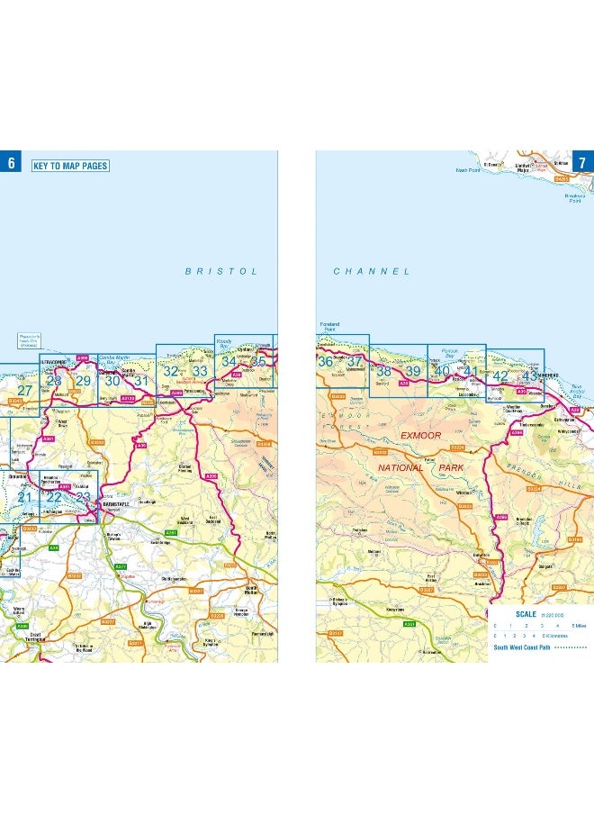
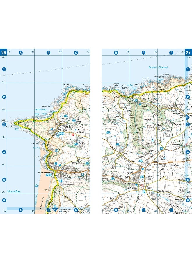
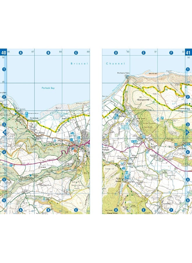
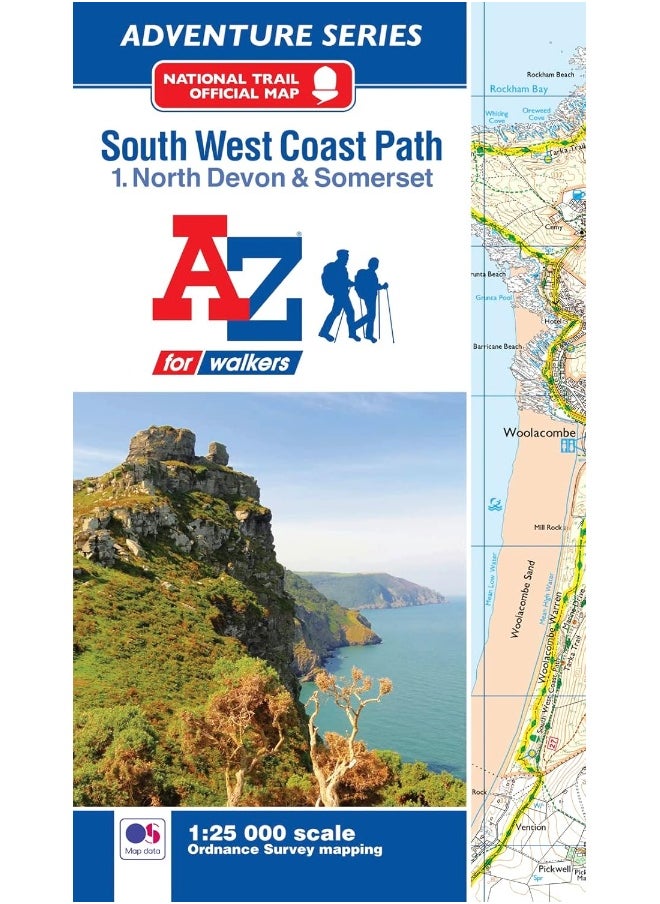
| Book Description | The perfect companion for those who love the great outdoors, the A-Z Adventure Series features OS 1:25000 mapping in a convenient book, complete with index.The South West Coast Path is a National Trail along the Somerset, Devon, Cornwall and Dorset coasts. This stunning walk from Minehead, Somerset covers 630 miles to South Haven Point in Poole Harbour, passing through two World Heritage Sites (the Jurassic Coast and the Cornwall and West Devon Mining Landscape), Exmoor National Park, Land's End and many areas of outstanding natural beauty.A series of five A-Z Adventure Atlases together cover the South West Coast Path:•SW Coast Path North Devon and Somerset•SW Coast Path North Cornwall•SW Coast Path South Cornwall•SW Coast Path South Devon•SW Coast Path DorsetThis A-Z Adventure Atlas of the SW Coast Path North Devon and Somerset features 36 pages of continuous OS mapping covering the route from Minehead to Bude. The trail is easy to follow, highlighted in yellow to stand out from other footpaths, with mileage markers to gauge distances when planning your own sections of the walk to enjoy.The book includes a route planner showing distances between places and indicates available amenities, including:•Information Centres•Visitor Centres•Hotels/B&Bs•Youth Hostels•Campsites (seasonal opening)•Public Houses•Shops•Restaurants•Cafes (seasonal opening)•Petrol stationsAlso featured is a selection of QR codes to access useful websites with your smartphone.Unlike original OS Explorer sheets, this A-Z Adventure Atlas includes a comprehensive index to towns, villages, hamlets and locations, natural features, nature reserves, car parks and youth hostels. Each index entry has a simple page reference and a six figure National Grid reference.OS 1:25000 is Ordnance Survey's most detailed leisure mapping, showing public rights of way, open access land, national parks, tourist information, car parks, public houses and camping and caravan sites.With a book size of 240mm x 134mm Adventure Atlases are the same size as a folded OS map, ideal for map pockets etc.Other National Trails available within the A-Z Adventure Series include: Coast to Coast, Cotswold Way, North Downs Way, Pembrokeshire Coast Path, Pennine Way, South Downs Way, The Ridgeway and Thames Path. |
 Free & Easy Returns
 Best Deals


![/fashion-men/jack_jones/?sort[by]=popularity&sort[dir]=desc&limit=50](https://a.nooncdn.com/cms/pages/20240305/4ef48af441e2b44cea1673cd2e4aff67/en_dk-men-brands-04.png)


![/fashion-men/seventy_five/?sort[by]=popularity&sort[dir]=desc&limit=50](https://a.nooncdn.com/cms/pages/20240305/4ef48af441e2b44cea1673cd2e4aff67/en_dk-womens-new-brands-01.png)
![/fashion-men/skechers/?sort[by]=popularity&sort[dir]=desc&limit=50](https://a.nooncdn.com/cms/pages/20240305/4ef48af441e2b44cea1673cd2e4aff67/en_dk-womens-new-brands-02.png)


![/fashion-women/mango/?sort[by]=popularity&sort[dir]=desc&limit=50](https://a.nooncdn.com/cms/pages/20240305/4ef48af441e2b44cea1673cd2e4aff67/en_dk-women-brands-05.png)
![/fashion-women/guess/?sort[by]=popularity&sort[dir]=desc&limit=50](https://a.nooncdn.com/cms/pages/20240305/4ef48af441e2b44cea1673cd2e4aff67/en_dk-women-brands-09.png)


![/fashion-women/ella/?sort[by]=popularity&sort[dir]=desc&limit=50](https://a.nooncdn.com/cms/pages/20241812/en_dk-nav-brands-01.png)
![/fashion-women/skechers/?sort[by]=popularity&sort[dir]=desc&limit=50](https://a.nooncdn.com/cms/pages/20241812/en_dk-nav-brands-02.png)


![/fashion/view-all-kids-clothing/nike/?sort[by]=popularity&sort[dir]=desc&limit=50](https://a.nooncdn.com/cms/pages/20240911/nav-web/en_mb_uae_brand-01.png)
![/fashion/view-all-kids-clothing/disney/disney_minnie_mouse/disney_frozen/disney_princess/disney_mickey_mouse/disney_baby/?sort[by]=popularity&sort[dir]=desc&limit=50](https://a.nooncdn.com/cms/pages/20240911/nav-web/en_mb_uae_brand-03.png)


![/fashion/view-all-kids-clothing/new_balance/?sort[by]=popularity&sort[dir]=desc&limit=50](https://a.nooncdn.com/cms/pages/20240911/nav-web/en_mb_uae_brand-11.png)


![/baby-products/momcozy/?f[partner][]=p_9404&sort[by]=popularity&sort[dir]=desc&limit=50&page=1&isCarouselView=false&av=0](https://a.nooncdn.com/cms/pages/20241031/navrev-baby/en_uae_dk-nav-04.png)


![/music-movies-and-tv-shows/musical-instruments-24670/pianos-keyboards-synthesizers/roland/?sort[by]=popularity&sort[dir]=desc&limit=50&page=1&isCarouselView=false](https://f.nooncdn.com/cms/pages/20250407/books-nav/en_uae_dk-nav-brands-05.png)
![/music-movies-and-tv-shows/musical-instruments-24670/pianos-keyboards-synthesizers/mike_music/?sort[by]=popularity&sort[dir]=desc&limit=50&page=1&isCarouselView=false](https://f.nooncdn.com/cms/pages/20250407/books-nav/en_ksa_dk-nav-brands-04.png)


