Free & Easy Returns
 Best Deals


| Publisher | Packt Publishing |
| ISBN 10 | 178398466X |
| Language | English |
| Publication Date | 27 December 2014 |
| ISBN 13 | 9781783984664 |
| Author | Erik Westra |
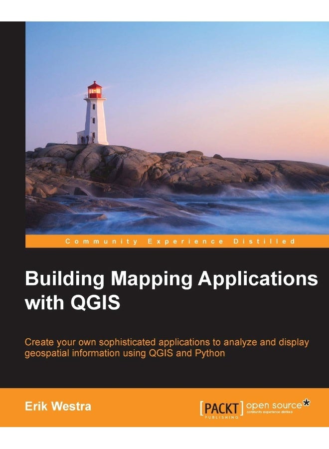
| Book Description | Create your own sophisticated applications to analyze and display geospatial information using QGIS and PythonAbout This BookMake use of the geospatial capabilities of QGIS within your Python programsBuild complete standalone mapping applications based on QGIS and PythonUse QGIS as a Python geospatial development environmentWho This Book Is ForIf you are an experienced Python developer who wants to create your own geospatial applications with minimum fuss, this is the book for you. While some familiarity with mapping applications would be an advantage, no prior knowledge of geospatial concepts is required. Even if you've never used QGIS before, this book will quickly get you up to speed.What You Will LearnUse the Python Console to explore and control QGISPerform geospatial development tasks using the PyQGIS Python libraryCreate useful geospatial applications implemented as QGIS Python pluginsUse QGIS as a standalone geoprocessing library within your Python programsBuild complex interactive map-based GUIs within your own Python programsUnderstand how Python scripting can be used to customize the QGIS systemUtilize the true potential of Python and QGIS to create your own complete mapping applicationsIn DetailQGIS is one of the premiere open source Geographical Information Systems. While developing Python geospatial applications can be challenging, QGIS simplifies the process by combining the necessary geoprocessing libraries with a sophisticated user interface, all of which can be directly controlled using Python code.Starting with an introduction to QGIS and how to use the built-in QGIS Python Console, we will teach you how to write Python code that makes use of the geospatial capabilities of QGIS. Building on this, you will ultimately learn how to create your own sophisticated standalone mapping applications built on top of QGIS. You will learn how to use the Python Console as a window into the QGIS programming environment, and then use that environment to create your own Python scripts and plugins to customize QGIS. As your knowledge of the PyQGIS library grows, you will use it to perform a variety of real-world geospatial programming tasks, culminating in the creation of your own complex standalone applications to load, analyze, and display geospatial data. |
| Number of Pages | 264 pages |


![/fashion-men/jack_jones/?sort[by]=popularity&sort[dir]=desc&limit=50](https://a.nooncdn.com/cms/pages/20240305/4ef48af441e2b44cea1673cd2e4aff67/en_dk-men-brands-04.png)


![/fashion-men/seventy_five/?sort[by]=popularity&sort[dir]=desc&limit=50](https://a.nooncdn.com/cms/pages/20240305/4ef48af441e2b44cea1673cd2e4aff67/en_dk-womens-new-brands-01.png)
![/fashion-men/skechers/?sort[by]=popularity&sort[dir]=desc&limit=50](https://a.nooncdn.com/cms/pages/20240305/4ef48af441e2b44cea1673cd2e4aff67/en_dk-womens-new-brands-02.png)


![/fashion-women/mango/?sort[by]=popularity&sort[dir]=desc&limit=50](https://a.nooncdn.com/cms/pages/20240305/4ef48af441e2b44cea1673cd2e4aff67/en_dk-women-brands-05.png)
![/fashion-women/guess/?sort[by]=popularity&sort[dir]=desc&limit=50](https://a.nooncdn.com/cms/pages/20240305/4ef48af441e2b44cea1673cd2e4aff67/en_dk-women-brands-09.png)


![/fashion-women/ella/?sort[by]=popularity&sort[dir]=desc&limit=50](https://a.nooncdn.com/cms/pages/20241812/en_dk-nav-brands-01.png)
![/fashion-women/skechers/?sort[by]=popularity&sort[dir]=desc&limit=50](https://a.nooncdn.com/cms/pages/20241812/en_dk-nav-brands-02.png)


![/fashion/view-all-kids-clothing/nike/?sort[by]=popularity&sort[dir]=desc&limit=50](https://a.nooncdn.com/cms/pages/20240911/nav-web/en_mb_uae_brand-01.png)
![/fashion/view-all-kids-clothing/disney/disney_minnie_mouse/disney_frozen/disney_princess/disney_mickey_mouse/disney_baby/?sort[by]=popularity&sort[dir]=desc&limit=50](https://a.nooncdn.com/cms/pages/20240911/nav-web/en_mb_uae_brand-03.png)


![/fashion/view-all-kids-clothing/new_balance/?sort[by]=popularity&sort[dir]=desc&limit=50](https://a.nooncdn.com/cms/pages/20240911/nav-web/en_mb_uae_brand-11.png)


![/music-movies-and-tv-shows/musical-instruments-24670/pianos-keyboards-synthesizers/chloris/?sort[by]=popularity&sort[dir]=desc&limit=50&page=1&isCarouselView=false](https://f.nooncdn.com/cms/pages/20250407/books-nav/en_uae_dk-nav-brands-04.png)
![/music-movies-and-tv-shows/musical-instruments-24670/pianos-keyboards-synthesizers/roland/?sort[by]=popularity&sort[dir]=desc&limit=50&page=1&isCarouselView=false](https://f.nooncdn.com/cms/pages/20250407/books-nav/en_uae_dk-nav-brands-05.png)
![/music-movies-and-tv-shows/musical-instruments-24670/pianos-keyboards-synthesizers/donner/?sort[by]=popularity&sort[dir]=desc&limit=50&page=1&isCarouselView=false](https://f.nooncdn.com/cms/pages/20250407/books-nav/en_uae_dk-nav-brands-06.png)
![/music-movies-and-tv-shows/musical-instruments-24670/pianos-keyboards-synthesizers/korg/?sort[by]=popularity&sort[dir]=desc&limit=50&page=1&isCarouselView=false](https://f.nooncdn.com/cms/pages/20250407/books-nav/en_uae_dk-nav-brands-07.png)